What am I up to

Friday, October 22, 2010

Footsteps around


__________________________________________________________________________________
Acknowledgments 
 During the week I spent in Pendleton, Oregon I meet so many people of the Confederated Tribes of the Umatilla and experienced hospitality you would receive as if you were at home, my acknowledgement section may appear long, but does not give justice to the true hospitality I have received.

Firstly many, many thanks must go to Andrew Wildbill whom took time from his University studies at Michigan State University, Michigan to travel to his homeland in Oregon to assist me on my Fellowship. To Michelle Thompson, Andrew’s mum and ALL her family, whom I now consider a part of my family a big thank you.

I would like to pay a thank you to all the staff at the Confederated Tribes of the Umatilla, Natural Resource Department and in particular to Director Eric Quaempts  for allowing his staff to assist me, namely;
·         Teara Farrow Ferman, Program Manager, Cultural Resources Protection
·         Gary James, Fisheries Programs Manager
·         Gordy Schumacher, Program Manager, Range, Ag & Forestry
·         Carl Scheeler, Wildlife Program Manager
The above are heads of departments and there are many of their staff whom 
assisted me during my research, so a big thanks must be given to them also.

Thank you to the Tribal Government for allowing me time with your people


 Four Chief's of the Confederated Tribes of the Umatilla


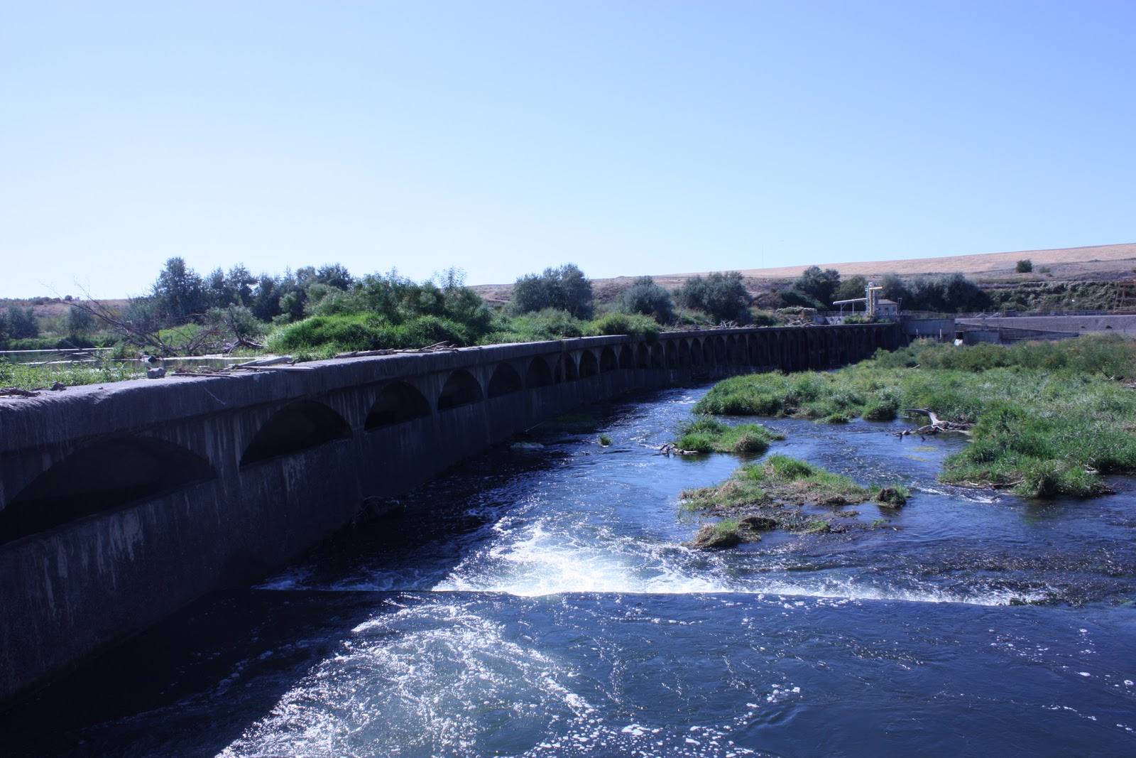
River Revegetation project funded by the Umatilla Tribe


Salmon migrating up the fish ladder at the McNary Lock and Dam


Fish migration apparatus used on the Columbia River
The Columbia River is the largest river in the Pacific Northwest region of North America. The river rises in the Rocky Mountains of British Columbia, Canada, flows northwest and then south into the U.S State of Washington, then turns west to form most of the border between Washington and the state of Oregon before emptying into the Pacific Ocean  


Fish ladder on a In-let to the Columbia River funded by the Umatilla Tribe


Tamastslikt Cultural Centre and Museum 


Monday, September 13, 2010

Tracks to Pendleton, Oregon.

Just heading to Pendleton, Oregon with my Native American Indian friend Andrew Wildbill. Andrew is from the Umatilla tribe.


The Cayuse, Umatilla and Walla Walla people make up the Confederated Tribes of the Umatilla Indian Reservation.
Since time immemorial, they have lived on the Columbia River Plateau. Specifically, their homeland is the area now known as northeastern Oregon and southeastern Washington.

The three bands were brought together on the Umatilla Indian Reservation, established by a Treaty with the US Government in 1855. They were united as a single tribal government in 1949 when the leaders adopted their Constitution and By-laws.

The Cayuse, Umatilla and Walla Walla people currently have over 2,800 tribal members. They are a small group of people who continue to care for and live on the land of their ancestors. They are a small group of people who are doing great things for themselves and their neighbors.


(source: http://www.umatilla.nsn.us/)

Saturday, September 11, 2010

Footprints at Mount St.Helens

Today, again another lifetime experience. I visited Mount St Helens, in Southwestern Washington State. The weather wasn't kind but as Mother Nature intended, my gratitude is being able to visit this most amazing place.

Before Mt. St. Helens blew its top is was a beautifully symmetric rounded snow-capped mountain that stood between two powerfully jagged peaks Mt. Hood ( which Indians called Wy'east) and Mt. Adams ( which Indians called Klickitat). According to one Indian legend, the mountain was once a beautiful maiden, "Loowit".   When two sons of the Great Spirit "Sahale" fell in love with her, she could not choose between them. The two braves, Wyeast and Klickitat fought over her, burying villages and forests in the process ( hurling rocks as they erupted?). Sahale was furious. He smote the three lovers and erected a mighty mountain peak where each fell. Because Loowit was beautiful, her mountain (Mount St. Helens) was a beautiful, symmetrical cone of dazzling white. Wyeast (Mount Hood) lifts his head in pride, but Klickitat (Mount Adams) wept to see the beautiful maiden wrapped in snow, so he bends his head as he gazes on St. Helens.  This is one of many indian legends involving Mount St. Helens.
(information http://www.mountsthelens.com/history-1.html)

May 18 1980, a Sunday, dawned bright and clear. At 7 a.m. Pacific Daylight Time (PDT), USGS volcanologist David A. Johnston, who had Saturday-night duty at an observation post about 6 miles north of the volcano, radioed in the results of some laser-beam measurements he had made moments earlier that morning. Even considering these measurements, the status of Mount St. Helens' activity that day showed no change from the pattern of the preceding month. Volcano-monitoring data--seismic, rate of bulge movement, sulfur-dioxide gas emission, and ground temperature--revealed no unusual changes that could be taken as warning signals for the catastrophe that would strike about an hour and a half later. About 20 seconds after 8:32 a.m. PDT, apparently in response to a magnitude 5.1 earthquake about 1 mile beneath the volcano, the bulged, unstable north flank of Mount St. Helens suddenly began to collapse, triggering a rapid and tragic train of events that resulted in widespread devastation and the loss of 57 people, including volcanologist Johnston.
(information http://www.mountsthelens.com/history-1.html)


On my footsteps around the World this is one of the most amazing places I have visited and am honored to be able to see such might Mother Nature creates


Thursday, September 9, 2010

Footsteps with the Puyallup Tribe of Indians, Washington

Well today I visited the Puyallup Tribe of Indians. The Puyallup Indians have lived along the shores of Puget Sound in the State of Washington for thousands of years. In their native language they were known as S'Puyalupubsh, meaning "generous and welcoming behavior to all people (friends and strangers) who enter their lands." The membership of the Tribe has grown considerably, and is now in excess of 3,800 people.


I visited their Natural Resource Centre where their director Mr Bill Sullivan introduced me to the management of their tribal natural resource management operations.


I then visited the Cultural operation of the The Puyallup Indians where their Culture is documented, recorded and restored. Brandon Raynon is the tribal groups Tribal Archaeologist and Cultural regulatory specialist. 


The Tribe works to ensure that all aspect of their cultural program is incorporated in their natural resource management operations


Thank you Bill Sullivan (NRM), Brandon Raynon and Judy Wright (Historic Preservation) and also Paul Arnold (GIS Analyst) for taking the time to show me around your center and to let me gain insight into the Puyallup Tribe of 
Indians

Wednesday, September 8, 2010

Stepping to the Payullap Tribe


Today is my first visit to the Payullap Tribe of Native American Indians based in Tacoma, Washington.

Payullap Tribal emblem 

Sunday, September 5, 2010

Stepping at Ellensburg

The last couple of day have been spent at Ellensburg, Washington at the famous Ellensburg rodeo. Cousin Tina plays in a pipe band (bagpipes) and the team were in the parade.

Friday, September 3, 2010

Stepping out to Microsoft

Wow, What a lovely day in Seattle. Weather is just like Toowoomba. Off to Microsoft for a grand tour with another cousin who works there. Going with my Cousin Tina, John and Bev.
My Cousin Gerry-Ann works at Microsoft


Me and the Microsoft Inventors